3D and Flat Eritrea Map - Vector Image Vector Graphic
Premium
Subscribe to unlock unlimited access to 397000+ premium assets
Share:
Authorization required
Added to collection Add to collection

Short description:
Vector map of the Eritrea drawn with high detail and accuracy.colored with flag tones.
It is a well organized file with many layers and you can change the 3d directions as you want and you can change the colors.
File Information:
—-—-—-—-—-—-—--
3D and Flat Eritrea map
Ai, EPS and JPG File
Fully Editable
300 dpi
RGB color system
Easy to Customize
—-—-—-—-—-—-—-
Please if you like this project, Vote 5 stars for it :)
thank you :)
Show more hide
Similar Graphics
see all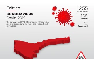
Authorization required
Authorization required

Authorization required
Authorization required

Authorization required
Authorization required
More From Graphicsline
see all
1 Authorization required

Authorization required

Authorization required

Authorization required

Authorization required

Authorization required
Additional info