USA Infographic Map | Editable Vector & Printable | Customizable States | Data Visualization
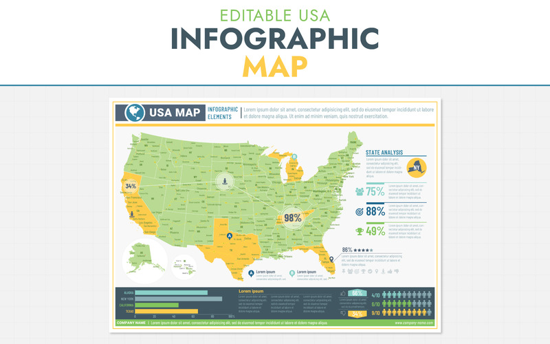
Create your own custom USA maps – fully editable & printable!
This high-quality infographic map includes all 50 states, major cities, and lots of details, all in fully layered vector formats. Perfect for designers, educators, bloggers, and anyone who wants to make unique maps for print, presentations, websites, and more.
What’s Included
- All 50 states as separate vector shapes – customize colors, borders, and styles
- State names and many city names included
- Editable live charts – add your own data directly in Illustrator
File types:
- Adobe Illustrator CC (layered vector)
- Adobe Photoshop CC (layered shapes, still vector)
- EPS 10 (vector)
- PDF (layered)
- JPEG preview
Technical Details
- Colors: CMYK
- Page size: A1 landscape (AI & EPS), PSD: 4967×3508 px
- Fonts included: Roboto, Roboto Condensed, Barlow Condensed (links in info file)
Perfect For
- Print posters, planners, or stickers
- Web graphics, infographics, and social media posts
- Education and classroom materials
- Marketing materials, reports, and presentations
Why You’ll Love It
- Fully editable and scalable without losing quality
- Instant digital download – start customizing immediately
- Easy to personalize – no professional skills required
- Great for teachers, bloggers, small business owners, and creatives
Bonus Ideas & Tips
- Use for home décor, office wall art, or classroom projects
- Ideal for data visualization and infographics
Support & Help
If you have any questions or technical issues, just send me a message – I’m happy to help!
Thank you!
License: Premium More info
Tags:
Images included:
Requirements for software and hosting:
 Adobe Photoshop CC+
  Adobe Illustrator CS2